SHIPWRECK SECTION
KEYS SITES:
SAN JOSE - (N24° 55.46 W80° 28.53)
one of the 1733 Spanish Galleon Fleet that was struck by a hurricane
as it struggled up the Florida Coast, off present day Marathon. The
San Jose was carrying almost 7 million pesos in gold when she sank,
and was salvaged by both Spanish and modern day salvors. Due to the
archaic methods of the early, salvors and the scattered remains found
by modern salvors, it appears the treasure will never run dry for the
weekend potluck hunters of today. The ballast pile is in 35 feet of
water but largely covered by sand, although the conditions are usually
clear. Most recoveries were made directly S. of the wreck-site, but
the area to the N. of the wreck has been largely unexplored, and the
backside of the hurricane that hit this fleet (moving west) was driving
survivors and remnants of the ship due north. For the pot-hunter, the
northern sand patches and areas next to reefs may pay off with recoveries
of passenger's personal items.
HERRERA - another of the 1733 Galleon Fleet wrecks, this ship is also
known as the "figurine" wreck due to the hundreds of animal
figurines found on the site. Even though this site has been heavily
worked, it still produces figurines for the potluck hunter willing
to work the sand patch to the Northeast of the ballast pile. These
figurines must be preserved or they will crumble shortly after recovery!
Soaking the figurine in distilled water for two years removes the salt,
at which time a thinned (with water) layer of Elmers Glue All is applied,
after the outside surface dries, to keep the figurine from cracking.
Figurines from this wreck are almost 300 years old, please don't bring
them up if you're not prepared to preserve them!
SLOBDONA - (N25° 01 W80° 38) an Austrian sailing vessel that
sank just south and shoreward of the Molasses Reef Tower in 1887, is
not valuable for the wreck itself, but for the objects left behind
by divers that visit! The wreckage lies in a large sand patch, and
is composed of rigging and scattered iron pieces.
ANCHOR SITE -- (N25° 01 W80° 38) A large Spanish anchor is located
14' east of Marker 21 on Molassas Reef. Visitors often drop jewelry into the
sands beneath the popular anchor site, at buoy 21.
SAN PEDRO - (N24° 51.90' W80° 40.72') This ship was part of the 1733
Galleon Fleet sunk in a hurricane. The wreck location is 1.25 nautical miles
off Lower Matecumbe Key and 1 nautical mile off Indian Key. The site is well
buoyed by the State, easily spotted once past Indian Key, and is visited by
hundreds of boats from Marathon and elsewhere each year. Protected as part
of Florida's Underwater Park System the ship itself is off limits to salvors,
but the pot hunter is mainly concerned with the fact that survivors of the
ship swam 1 nautical mile to Indian Key. Hundreds of Spaniards, many heavily
weighted with smuggled gold and emeralds, undoubtedly dropped their personal
fortunes all along that harrowing route. I believe a line drawn from the shipwreck
to the key, and 50 yards to either side, would outline a rewarding area to
search, as the professional salvage companies had no time for small scale searching,
and the Spanish salvors were unconcerned with personal losses. There are many
bare sand patches in a line from the wreck to the key, and any of these could
yield a fortune in gold and emerald jewelry!
ANGUSTIAS - (N24° 47.27 W80° 51.52) was a source of major treasure
recoveries when initially salvaged in the early 1970's. Part of the 1733 treasure
fleet that deposited 20,000,000 pesos of silver and gold (Weller, 91), along
the Florida reefs, this wreck's crew and passengers swam for nearby Long Key,
with many losing their lives. After extensive salvage by both Spanish and modern
day treasure hunters, it would seem the prudent hunter would draw a line from
the wreck directly north to Long Key Bridge and search the areas 50 yards to
either side of the line. My reasoning is: this was the route survivors had
to swim due to the prevailing current of the channel at the time the ship sunk.
The account of a survivor of the wreck details his saving, by floating on wreckage
towards Long Key, so the current must have been favorable to drift near the
key. If it had been otherwise, with the backside hurricane winds blowing against
the tidal currents running under Long Key Bridge, the extremely steep seas
created would have insured there would be no survivors at all. Either a few
of the passengers (or their remains) deposited gold on the south end of Long
Key, or the salvage camp for this ship was located on the south shore, as metal
detector users occasionally find 1733 coins here. Of these two possibilities,
I believe the latter. Diving conditions on the Angustias are spotty. Silt frequently
dims visibility when the current is from the Long Key Bridge, and the ballast
is infested with eels and frequented by sharks. By hunting the areas away from
the wreck, some of these problems can be eliminated.
ELLIOT KEY WRECK SITE -- (N25° 24.70 W80° 10.64) in 1990 I don't know
if this could be the wreck of the cargo ship transporting Union supplies or
not, but whoever they were, they sank with a full complement of dishware, crockery,
bottles etc. In general, the upper keys off Elliot Key are not much explored,
which I find strange since it is much clearer water than anywhere else in the
Keys. Perhaps people don't think they've been to the keys unless they go on
the overseas highway, I don't know, but it is superior diving off Elliot Key,
and there are virgin wrecks yet to find!
1733 FLEET WRECK: EL POPULO -- (N25° 21.85, W80° 09.690) State site
file #8MO147. What you'll find here is scattered ballast and some timbers.
There was one Pillar Dollar recorded as being found on the wreck, along with
cannon and personal artifacts. There is some contention amongst treasure hunters
that this might be the advice boat of the 1733 fleet, and the Populo is further
towards Caesar's Creek.
1733 FLEET WRECK: EL INFANTE -- (N24° 56.57 W80° 28.58) was one of
the two major treasure galleons of the ill fated 1733 fleet. The ship was built
in 1724, was 326 tons and carried 40 cannon. Art McKee was the first diver
to salvage the wreck and worked it for over 20 years. Even so, much remains,
as its shallow location resulted in wave action dispersing the treasure far
from the site. Almost any reef within reasonable distance will trap coins from
this ship. Going out of Key Largo Harbor to Little Conch Reef will get you
reasonably close to the co-ordinates (ship actually on Fire Coral Shoal). There
is a huge ballast pile in 12 feet of water, so snorkelers can have fun here
too.
SHIPWRECKS FROM ADMIRALTY FINAL RECORD BOOK
FOR U.S. DISTRICT COURT FOR
THE SOUTHERN DISTRICT OF FLORIDA, volume 2-19, microfilm number 1360, roll
2 - 19, any number following a listing is the actual account number in the
reel, so you can trace the information also. This information was boiled out
of an index of all ship mishaps compiled by Tom Hambright, of the Monroe County
Public Library, Key West, Florida, in 1988.
There are many shipwreck books on
the market with lists of ships taken from the admiralty records; however, what
is not commonly included (in fact, I have never seen it included) are facts
from the records on what the disposition of the ship was after it wrecked.
In the admiralty records themselves, is listed right after the wreck the disposition,
and roughly 85% were refloated, broken up for scrap, or completely
salvaged. So, out of the average shipwreck book's list of losses, toss
away 85% of the wrecks listed, and you have about the number actually
on the bottom.
In the list that follows, are only wrecks that were lost,
so if you look for one, at least you have a shot at finding something. Where
coordinates are given, they are for the reef where the ship was lost.
SYLPHIDE:
lost 21 Dec. 1850 on Loggerhead Key, Dry Tortugas.
TAGLIONI: lost April 7, 1848, Carysfort Reef, passengers & assorted cargo
aboard. (N25° 13.30 W82° 12.70)
TARTAR: brigantine, lost January 4, 1855 on East Key, Dry Tortugas with a cargo
of rice.
TELUMAK: lost November 18, 1845 on Biscayne Reef, with assorted cargo aboard
from Liverpool.
TENNFAUTE: brigantine, lost February 18, 1839 at Boca Raton, with cotton and
cigars aboard.
VICTOR: lost November 20, 1872 at Jupiter inlet with assorted cargo aboard
from New York.
TILAMON: lost January 12, 1852 on Delta Shoals with assorted cargo from New
York.
THOMAS de RESA: bark, lost October 6, 1870 on Turtle Reef with a cargo of staves.
TONAWANDA: steamer, lost March 29, 1866 on Elbow Reef. (N25° 08.61 W80° 15.79)
THALES: bark, lost January 17, 1859 in the Hillsborough River with a cargo
of wine, brandy, and lumber. If this wreck is found, I would like to have one
of the bottles, please.
THREE SISTERS: brigantine, lost October 13, 1870 on Cape Florida (Key Biscayne)
with a cargo of lumber from Nova Scotia.
TIGER: brigantine, lost February 18, 1860 on Eastern Sandbores.
ZOTOF: ship, lost December 15, 1844 on Loggerhead Key, Dry Tortugas with cotton,
flour, lead, and sugar from New Orleans aboard.
SOUTH AMERICAN: bark, lost September 5, 1900 on French Reef with a cargo of
Mahogany aboard.
SPARKLING SEA: ship, lost January 8, 1863 on Ajax Reef with troops and supplies
from Fort Monroe aboard. This would be a good one to find! (N25° 24.69
W80° 07.61)
St. JAMES: ship, lost November 16, 1871 on Conch Reef with a load of railroad
iron.
WILLIAM M JONES: schooner, lost January 24, 1877 on Polaski Shoal, Dry Tortugas
with sugar, rice, and syrup aboard.
WOODSIDE: ship, lost December 31, 1852 on Ledbury Reef with timber aboard.
(N25° 32.79 W80° 06.06)
YUCATAN: brigantine, lost April 20, 1847 on French Reef with a cargo of cotton,
lard, pork, and flour aboard.
WESTERN EMPIRE: ship, lost November 3, 1875 in the Indian River. 6460.11 11
376
SCANDINAVIA: brigantine, lost March 18, 1867 on Conch Reef with a load of timber.
1281.79 10 308.
SEA LARK: brigantine, lost November 08, 1865 at Spanish Harbor. 1841.16 10
99.
SEA SIDE: brigantine, lost November 13, 1879 off Sand Key near Key West. 400.00
12 676.
WALTHAM: bark, lost October 23, 1865 at Matecumbe Key, with a cargo of cotton,
wool, and hides. 18196.01 10 66.
WANDERING CHIEF: bark, lost September 24, 1884 on Elbow Reef. 1597.50 16 44.
(N25° 08.61 W80° 15.79)
SARAH ANN: schooner, from Charleston bound for Mobile, lost September 6, 1837
on Sombrero Reef. 574.91 2 91.
SAXONY: ship, lost April 18, 1854, 50 miles N of Cape Florida with a cargo
of white pine aboard. 921.58 5 258.
ROSALINA: brigantine, lost June 28, 1837 on Pickles Reef with a cargo of Jamaica
London Rum, sugar, and mahogany aboard. 2577.84 2 30. Please send us a bottle
of the rum!
RUDOLPH GRONING: brigantine, from New York to Apalachicola with assorted cargo
aboard, lost June 01, 1843, on Southwest Reef, Dry Tortugas. This shipwreck
could have many personal effects of wealthy Tallahassee families, or war cargo
from the 3rd Seminole War aboard! 9530.32 3 160.
GUTENBERG: bark, lost December 15, 1885 at Bird Key, Dry Tortugas, with a cargo
of cotton, cottonseed, and staves aboard. 20702.26 13 579.
RIVER SMITH: lost February 9, 1858, at Carysfort Reef with a load of salt aboard.
1046.37 6 45. (N25° 13.30 W80° 12.70)
ROBERT MORRIS: bark, lost July 21, 1853 on Pelican Shoals with a cargo of sugar
aboard. 2531.24 5 91.
GEORGE P. SLOATE: lost December 27, 1855 at Charlotte Harbor with a load of
brick aboard. 798.91 5 435.
GLAMO: bark, lost June 1, 1905 on Marquesas Reef with a cargo of staves. 7696.58
19 60.
RELAMPAGO: schooner, lost February 16, 1849, at Key West. She carried 246 New
Orleans to San Francisco passengers that had paid $125.00 for fare. There may
be much more money aboard, and numismatic values being what they are, this
could be a good wreck to find!
Rienri: ship, lost May 15, 1845 on Pickles Reef, bound from New York to New
Orleans with an assorted cargo aboard. Any ship with "assorted cargo" aboard
stands the chance of being a very good find, as "assorted" was usually
code word for contraband, military cargo, personal belongings, or individual
items suitable for sale. 617.38 3 240.
RINGOLD: schooner, lost October 23, 1865 in the Northwest Channel with red
cedar aboard. Bound from Chassahowitzka River to New York.
FRANCIS ASHBY: brigantine, lost January 20, 1843 on Loggerhead Key (American
Shoals) with a cargo of coffee, honey, and tobacco aboard. 573.00 3 125.
FRANKLIN: brigantine, lost May 13, 1861 on Conch Reef with a load of sugar
aboard. 2049.34 7 633.
PILITA: brigantine, lost May 2, 1851 on Carysfort Reef with sugar and coca
aboard. Ship was found with no crew aboard (doo doo dee doo!). 2492.93 4 511.
(N25° 13.30 W80° 12.70)
PRAIRIE BIRD: bark, lost June 16, 1875 at Key West with a cargo of cotton aboard.
14000.00 12 78.
FOLOMER: bark, lost March 2, 1881 on Southwest Reef, Dry Tortugas, with cotton
aboard. 6384.37 13 65.
FRANCES: ship, lost April 3, 1856 on Dog Rocks with ice aboard. 461.20 5 516.
PEQUOT: schooner, lost January 21 1842 on Washerwoman Shoals with tobacco,
beef, and pork aboard. 442.18 3 84.
PETRUS: brigantine, lost April 28, 1848 on Sombrero Reef. Money aboard saved
by crew (a curious notation), no further salvage.
4500.80 4 126.
PILGRAM: brigantine, lost November 17, 1843 on Bush Key, Dry Tortugas, with
whiskey, molasses, and lead aboard. The free blown whiskey bottles of this
era could be worth considerable money today! 6149.53 3 186.
FERONIA: bark, lost September 9, 1845 on Conch Reef with sugar and Jamaican
Rum aboard. See the above notation! 3200.00 4 227.
PACIFIC: bark, lost July 24 1857 on East Key, Dry Tortugas with assorted cargo
aboard. Could be a valuable find, see above notations about assorted cargoes.
9937.95 6 1.
PATRIARCA SAN JOSE: brigantine, lost November 1, 1870 on Pickles Reef with
furniture, hides, coffee, and other cargo aboard. 1816.74 11 72.
PEE DEE: schooner, lost November 4, 1837 at Biscayne Key with iron and coffee
aboard. 1384.86 2 107.
EVANDALE: ship, lost February 19, 1875 on French Reef with lumber aboard. 880.86
12 1.
EXCELSIOR: bark, lost May 23, 1880 on Grecian Shoals with sugar aboard. 1386.14
13 1.
EXPORT: brigantine, lost September 9, 1838 at Caesar's Creek with sugar aboard.
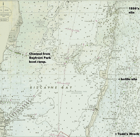
This would be good wreck to dive, since the Bayfront Park boat ramps are opposite
Caesar's Creek (Homestead, Fl., just N. of the Turkey Point power plant.) 1990.72
2 184. (N25° 23.17 W80° 13.68)
F. A. EVERETT: bark, lost January 8, 1853 on American Shoals. From Boston to
New Orleans with assorted cargo aboard. Could be a valuable find! See other
listings about "assorted." 9995.44 4 617.
ORACLE: bark, lost July 4, 1867 on Conch Reef with a load of mahogany aboard.
1391.93 10 362.
OSWINGO: ship, lost November 20, 1865 3/4 mile from Key West with coal aboard.
739.18 10 130.
ENERGIA: bark, lost December 30, 1877 on Molasses Reef with a cargo of grain
aboard. 799.21 12 449.
ENTERPRISE: schooner, lost July 11, 1859 at Jupiter inlet. Found with no crew
aboard. 1/2FS 6 352.
EARL KING: ship, lost December 15, 1891 at Caesar's Creek with assorted cargo
aboard. Could be valuable to find! See other listings about assorted cargoes!
2931.05 15 246. (N25° 23.17 W80° 13.68)
NORDYYN: bark, lost September 16, 1875 at Vacas Key with mahogany aboard. 463.84
12 103.
NORTH: brigantine, lost 65 miles N. of Cape Florida (Key Biscayne) with 1021
bales of cotton aboard (a bale weighed over a ton). 1515.81 6 44.
NORTH AMERICA: ship, lost November 25, 1842 on Delta Shoals with dry goods
and furniture aboard. 2257.44 3 103.
NORTHAMPTON: ship, lost May 24, 1883 on Molasses Reef with cotton and staves
aboard. 19285.61 13 346.
ELIZABETH BRUCE: ship, lost January 11, 1854 on Elbow Reef with crockery, ironware,
and other kitchenware aboard. From Liverpool to Mobile. Some of the crockery
could prove valuable. 3387.73 5 155. (N25° 08.65' W80° 15.77) (N25° 08.68
W80° 15.47)
ELIZABETH ELLEN: ship, lost December 3, 1859 45 miles N. of Cape Florida (Key
Biscayne). 14525.63 6 454.
EMIGRANT: bark, lost August 22, 1856 on Alligator Reef with cotton and oak
plank aboard. 13863.26 5 622.
NEWARK: ship, lost June 6, 1845 on Pickles Reef with cotton aboard.
4604.04 3 259.
NEW YORK: schooner, lost May 4, 1842 on Northwest Reef, Dry Tortugas with molasses
aboard. 929.45 3 57.
NOR' WESTER: ship, lost February 23, 1873 at Key West with cotton aboard. 26837.96
11 405.
ELENORA: ship, lost July 2, 1885 on Southwest Reef, Dry Tortugas, with lumber
aboard. 217.75 13 548.
ELIZA MALLORY: ship, lost November 4, 1859, 65 miles N. of Cape Florida (Key
Biscayne) with 4923 bales of cotton aboard. 16788.92 6 420.
ELIZABETH: schooner, lost June 12, 1847 on Florida Reef with honey and lignumvitae
aboard. 984.45 4 41.
ADELAYDA: schooner, lost March 26, 1863 on Elbow Reef with Dry Goods aboard.
7713.00 8 157. (N25° 08.64 W80° 15.77) (N25° 08.68 W80° 15.47)
HELEN E. BOOKER: ship, lost May 1, 1857 on Carysfort Reef with railroad iron
aboard. 21050.17 5 703. (N25° 13.30 W80° 12.70)
HENRY J.MAY: schooner, lost February 14, 1877 on Loggerhead Key, Dry Tortugas
with syrup aboard. 6599.50 12 318.
HERALD: brigantine, lost December 6, 1842 on Ledbury Reef with copper aboard.
1/3 c 3 119. (N25° 32.79 W80° 06.06)
HEBRUS: brigantine, lost March 10, 1838 on Pickles Reef with coffee and sugar
aboard. 1403.00 2 167.
AGAMEMNON: ship, lost February 12, 1853 on Yucatan Reef with flour, lard, and
staves aboard. 10872.64 6 52.
HORACE: bark, lost December 2, 1860 on Pickles Reef with lumber aboard. 576.87
6 574.
HYDER ALLY: schooner, lost September 15, 1838 on Marquesas Key Shoals with
a cargo of coffee, sugar, and cigars. 3000.00 2 189.
INDIAN HUNTER: ship, lost June 25, 1850 on French Reef, with 3,750 bales of
cotton aboard. 33852.62 6 323.
INDUSTRY: schooner, lost September 13, 1837, 45 miles north of Cape Florida
(Key Biscayne). 5408.90 2 75.
ALICIA: ship, lost April 25, 1905 on Long Reef with assorted goods from Liverpool
aboard. This could be a valuable find. 17690.80 19 95. (N25° 25.42 W80° 07.50)
AMAZON: bark, lost March 14, 1872 on Dry Rocks with a cargo of cotton. 10673.58
11 208.
ISABEL: bark, lost March 11, 1866 on Triumph Reef with a cargo of rum, sugar,
ginger, and hides aboard. 7561.33 10 208. (N25° 28.60 W80° 06.73)
ISABELLA REED: barge, lost February 14, 1850 on Conch Reef, sending molasses,
whiskey, sugar, and rope to the bottom. The whiskey bottles could be worth
considerable money today! 2980.00 4 427.
ISLAND HOME: bark, lost January 25, 1882 in the Marquesas Keys with lumber
aboard. 808.95 13 143.
ANGELA: brigantine, lost January 7, 1866 on Agamemnon Reef, 95 miles East of
Key West, with cotton, hides, dyewood, and other goods aboard. 5276.63 10 171.
JAMES W. LAURANCE: schooner, lost November 1, 1865 at the Middle Sand Bores,
with assorted cargo aboard. This could be a valuable find, for the "assorted" reasons
listed above. 3148.88 10 50.
ANNA M. STAMMER: schooner, lost December 6, 1863 on Duck Key with a cargo of
lumber. 1418.21 19 174.
ANNIE BALDWIN: bark, lost April 16, 1865 on Conch Reef. 734.59 8 672.
JANE ROSS: bark, lost December 5, 1867, 45 miles north of Cape Florida (Key
Biscayne) with a cargo of sugar, molasses, and asphaltum aboard.
JOHN WESLEY: bark, lost November 3, 1865, 20 miles north of Cape Florida (Key
Biscayne) with a cargo of 1460 bales of cotton.
AQUILLA: brigantine, lost March 16, 1871 on French Reef with a cargo of sugar.
4196.67 11 88.
JOSEPH BAKER: bark, lost January 13, 1891, on North Key, Dry Tortugas, with
a cargo of syrup and rice. 6104.91 15 90.
JOSEPH MEIGS: ship, lost July 14, 1863 on Foy (Fowey?) Rocks with Government
Stores aboard. This could be a valuable find. 1725.40 8 314.
ATHALIA: schooner, lost September 10, 1854 on Western Dry Rocks (sounds like
a Tortugas location) bound from New York for Apalachicola with an assorted
cargo aboard. This could be a valuable find. Look through the listings for "assorted." 11992.39
5 289.
ATHENAIS: ship, lost March 15, 1876 on the Quicksands (Marquesas). 284.26 12
166.
ATLANTIC: brigantine, lost April 6, 1865 on East Key, Dry Tortugas, with a
cargo of coal aboard. 850.00 8 664.
AURORA: bark, lost February 2, 1879 on Southwest Key, Dry Tortugas with lumber
aboard. 18.95 12 616.
L.W. MAXWELL: brigantine, lost September 24, 1854 on Eastern Dry Rocks with
mahogany and cedar aboard. 1510.50 5 270.
LADY FRANKLIN: bark, lost May 25, 1862, on French Reef with Jamaican rum, sugar,
honey, and logwood aboard. 3735.21 7 863.
BEN CUSHING: barge, lost February 22, 1862, on French reef with a cargo of
molasses and cigars. 380.00 7 723.
BREWSTER: ship, lost March 16, 1848, on Fowey Rock with cotton, hemp, lard,
and sugar as cargo. 4098.23 4 111. (N25° 35.45 W80° 05.80)
LET HER BE: brigantine, lost October 26, 1867 at Caesar's Creek (opposite Homestead
AFB), with a cargo of nails. 791.18 10 385. Most ships actually wrecked on
Caesar Creek Bank (N25° 22.71 W80° 12.87). (N25° 23.17 W80° 13.68
is the creek)
CANTON: ship, lost November 3, 1848, on Garden Key, Dry Tortugas, with a load
of cotton and flour aboard. 6286.30 4 191.
CARAQUENA: bark, lost November 5, 1858 at the Sandbores, with mahogany, logwood,
and hides aboard. 1723.27 6 219.
LONDON: bark, lost December 27, 1892 at the Quicksands with a cargo of lumber.
524.61 15 430.
CARMALITE COMPOSITE: bark, lost October 16, 1893 at Bird Key, Dry Tortugas
in ballast. Possible money to buy return cargo aboard. 446.92 15 542.
CAROLINE NESMITH: ship, lost October 23, 1865 on Carysfort Reef with 2500 bales
of cotton aboard. 60565.89 10 113. (N25° 13.30 W80° 12.70)
IVANISSIVECK: bark, lost January 31, 1889 at the Quicksands. 234.16 14 586.
CERRO GORDO: ship, lost October 13, 1860 at Loggerhead Reef, Dry Tortugas,
with a load of cotton. 1733.60 6 529.
CHARLES CROOKER: ship, lost November 7, 1859, 40 miles north of Cape Florida
(Key Biscayne). 19286.13 6 410.
CHARLES FIFTH: brigantine, lost December 7, 1842 on Carysfort Reef with sugar,
cigars, and tobacco aboard. 2396.35 3 113. (N25° 13.30 W80° 12.70)
CIMBUS: brigantine, lost March 17, 1853 on Western Dry Rocks (Tortugas). Had
a locomotive engine aboard among other assorted cargo. Could be a valuable
find. 8135.44 5 18.
MALVINA CEZARD: ship, lost August 15, 1861 on Pine Key Bar, with palm leaves,
mahogany, and fustic aboard. 1150.14 7 658.
MANCHESTER: ship, lost April 3, 1841 on Florida Reef. 575.77 2 381.
MARGARET KERR: ship, lost February 22, 1865 on Crokers Reef with a cargo of
sugar. 13898.59 8 629.
MARTHA GILCHRIST: bark, lost December 19, 1858 on North Key, Dry Tortugas,
with a load of bricks. 225.75 6 227.
CLARENDON: ship, lost May 9, 1858 at Double Head Shot Keys with a cargo of
sugar. 1591.14 6 88.
CLAUDINE: brigantine, lost March 23, 1841 on Florida Reef. 351.21 2 378.
MARINER: ship, lost March 12, 1856 on French Reef, with a cargo of salt. 3651.36
5 503.
MARS: brigantine, lost February 25, 1851 on Dry Rocks, with a cargo of molasses.
1010.03 4 493.
COLUMBIA: schooner, lost October 20, 1841 at Crayfish Key, Key West, with assorted
cargo aboard. Bound from Boston to Mobile. Could be a valuable salvage. 2556.83
3 7.
CONCORIDIA: ship, lost November 24, 1855 at Key Vacas. 190.00 5 388
CONSERVATIVE: brigantine, lost November 26, 1844 on Long Key Reef with cotton
and tallow aboard. 6278.69 3 209.
MARY COE: bark, lost November 4, 1859, 77 miles north of Cape Florida (Key
Biscayne) with 1172 bales of cotton. 6583.84 6 432.
MARY E. RIGGS: ship, lost April 22, 1879 on French Reef with cotton aboard.
44371.07 12 649.
MARY HALE: ship, lost January 11, 1856, on Kay Sal Banks with cotton, corn,
and rosin aboard. 12857.97 5 456.
MARY HOWLAND: ship, lost October 11, 1839 on Delta Shoals, from New York to
New Orleans with assorted cargo aboard. Could be a valuable salvage if found.
9860.55 2 301.
MARYLAND: ship, lost December 11, 1849 on Washerwoman Shoals, bound from Baltimore
to New Orleans with assorted cargo. Could be a valuable if found. 18468.00
4 350.
CORNWALL: bark, lost November 30, 1873 on Ajax Reef with mahogany, logwood,
and coconuts aboard. 2474.79 11 547. (N25° 24.69 W80° 07.61)
CORO NELLY: lost June 16, 1840 with coffee and sugar aboard. 15600.00 2 331.
CROWN: ship, lost January 22, 1857 on Ajax Reef with cotton, corn, and wheat
aboard. 23050.00 5 666 (N25° 24.69 W80° 07.61)
MATTHEW VAN BREE: bark, lost July 2, 1852 on Alligator Reef, with a cargo of
sugar. 7235.78 4 581.
MENEMON SANFORD: steamer, lost December 10, 1862 on Carysfort Reef. Bound from
New York to Ship's Island with Federal troops and Quartermaster's stores. Might
be worth a fortune if found with stores intact. 1753.00 8 29. (N25° 13.30
W80° 12.70)
MERCHANT: schooner, lost November 28, 1851 on Pacific Reef with U.S. mail,
rice, and $8,000.00 aboard. The numismatic value of $8000.00 in pre-1852 coins
(some or all could well be gold) could be a fortune to some lucky diver. 827.94
4 540. (N25° 22.30 W80° 08.50)
CUSHNOC: brigantine, lost June 2, 1853 NW of Cape Florida with sugar aboard.
943.22 5 48.
CYRUS BUTLER: brigantine, lost August 11, 1837 at Hillsboro Inlet with cotton
aboard. 3465.53 2 56.
DAHLIA: bark, lost May 11, 1865 on Pickles Reef with Jamaican rum, ginger,
hides, and pimento aboard. 3210.96 8 694.
MERRI ENGLAND: bark, lost January 16, 1878 on French Reef with a load of Mahogany.
239.50 12 464.
MINI: bark, lost January 29, 1859 on Pickles Reef with a load of cotton. 13420.00
6 272.
DIRECTOR: bark, lost March 21, 1862 on Carysfort Reef with a cargo of sugar,
ginger, and beeswax aboard. 3128.00 7 798. (N25° 13.30 W80.12.70)
MISSISSIPPI: lost April 21, 1874 on Fowey Rocks. Bound from Liverpool to New
Orleans with assorted cargo aboard. Could be a valuable find. 3114.74 11 595.
(N25° 35.45 W80° 05.80)
MORGA: brigantine, lost October 24, 1865, with flour and sardines aboard. 4088.27
10 26.
MULHOUSE: ship, lost March 27, 1859 at the Quicksands (Marquesas Keys) with
cotton and specie (coins) aboard. This one is worth finding! 27849.91 6 307.
DWIGHT: schooner, lost December 13, 1865, on Eastern Dry Rocks with mahogany
and hides aboard. 1638.55 10 164.
E.G. WILLARD: schooner, lost March 9, 1853 on Long Key with bacon, hams, beef,
and pork aboard. 5530.84 5 1.
E.J. WATTE: schooner, lost June 7, 1886 on Little Pelican Shoals with a load
of railroad iron. 10948.36 13 667.
N.M. TERRY: brigantine, lost November 7, 1864 on French Reef with coal aboard.
1864.66 8 504.
NADA: bark, lost September 26 1894 on Long Key with flour and staves aboard.
2694.00 18 27.
NANCY W. STEVENS: ship, lost September 12, 1849, at Loggerhead Key, Dry Tortugas,
with assorted cargo aboard. Could be valuable. 13761.00 4 336.
NATHAN HANNAU: ship, lost March 2, 1859 on Brewster Reef with a cargo of ice,
furniture, and shoes aboard. 1801.59 6 284.
NATHANIEL KEMBALL: ship, lost January 17, 1853 on Eastern Dry Rocks with 2550
bales of cotton. 19657.57 4 670.
NORTHWEST FLORIDA SHIPWRECKS:
ENGLISH NAVY COVE - is where the English
careened ships for bottom cleaning during their short occupation of
Florida, and in the process they lost at least three here. Two 1700's
era hulls are beginning to expose themselves in the bay. In Gulf Breeze,
Shoreline Road takes you past Shoreline Park and the first road to
the left (South) dead ends in the center of English Navy Cove. There
is an unknown wreck site just below East Point, almost on shore, at
N30° 21.56 W87° 11.30.
FORT PICKENS WRECK - (N30° 19.12 W87° 14.28) is almost on the Santa
Rosa beach, just West of the Pensacola beach.
AUDITORIUM WRECK - (N30° 24.13 W87° 13.15) is almost due W. of the
Pensacola Municipal Auditorium, at the end of the railroad wharf. This is probably
a historic wreck, due to the fact it has a ballast pile associated with it,
and it is at the foot of Old Pensacola's Historic District. The Auditorium
is at the foot of Palafox Street (US 29S.).
PENSACOLA BEACH WRECK -- (N30° 20.003 W87° 07.378) is roughly off the
end of Avenida 13 Street in 15 feet of water. The wreck is rock ballast, so
it is probably not an English war vessel, as they used iron ballast.
BRASS WRECK - (N30° 12.25 W87° 04.10) is so named after the brass pins
used to hold her planking to the ribs. Divers have broken off many of these,
but this is still a largely unexplored wreck, and due to the depth of the water
(90ft.) it is doubtful a thorough salvage was done when she sank, if at all.
The wreck sits on sand; use your depth finder to spot the large ballast mound
and anchor over the site. There is a good chance this ship is the BRIDE OF
LORNE, 1,324 tons, with a cargo of timber, under Captain Matson. She is listed
in Steven Singer's Shipwrecks of Florida as sinking very near this site, April
8, 1887. Ned DeLoach's Diving Guide to Underwater Florida gives a TD of 13365.7
47085.0 which is slightly different from my Lat./Long., but the wreck is so
large I believe either one will put you onto it, but probably at opposite ends.
FOX - (N29° 44.30 W84° 38.35) is a British naval schooner, 18 guns
150 tons, that sank SE of the modern day East Pass bell buoy to St. George's
Sound. This shipwreck is probably worth an extensive search, but is undoubtedly
covered with sand. A depth sounder, with its white-line recorder in on position,
may show ballast beneath the sand, and if not, a magnetometer will be needed.
Good luck, this could be a very rich site!
HATTIE G. McFARLAND - (N30° 19.30 W87° 18.80) a 546 ton bark sank Feb.
6, 1891 in ballast, quite near the wreck of the MISS JENNY (13248.8 47006.5)
a modern 55' boat. Use the Miss Jenny as your anchor point to find the wreck.
Ships of that time that sank "in ballast" typically had hard money
aboard to buy cargo!
UNKNOWN WRECKS! - are unknown wrecks from the NOAA surveys of 1982. (N30° 08.25
W85° 37.59) is located at the SW end of the old railroad wharf, at the
end of East Avenue in Springfield. Almost directly N. of this wreck, across
the railroad tracks in the branch of the bay that becomes Watson Bayou, is
another wreck at (N30° 08.43 W85° 37.54).
UNKNOWN WRECK - (N30° 19.12 W87° 14.28) is in the surf-line off Santa
Rosa Island and is a beach dive.
SOUTHWEST FLORIDA WRECKS:
BAJA CALIFORNIA -- (N25° 21.38 W82° 31.96)
was a Norwegian 1,648 ton freighter built in 1914 and carrying war
materials when torpedoed by U-84 roughly 60 miles off the Naples inlet.
The ship was out of New Orleans, bound for Guatemala when sunk. This
wreck is now a popular dive destination for charter boats operating
out of Naples. Depth at site: 115 ft.
STONEY POINT -- (N26° 10.11 W82° 54.61) this is the site of the former
Hudson River ferry that was scuttled in 1968. Now a popular site for diving.
The secret here is to metal detect the floor around the vessel for finds.
FANTASTICO -- (N26° 03.10 W82° 57.42) was the 200 ft. Honduran freighter
sunk in the March 19, 1993 "Storm of the Century" that inundated
the west coast of Florida with a tidal wave of water. Many people lost their
lives and property to this storm, much being washed into the tidal areas along
the coastline from Cedar Keys south to Naples.
NAPLES SPRING -- (N25° 50.45 W82° 09.21) is a possible Paleo site,
since artifacts have been found all the way out to the Florida Middle Grounds.
This freshwater spring in the Gulf is 80 feet across, 220 feet deep, with the
bowl dropping away from the sea floor at the 70 ft. depth level.
BAYRONTO -- (N26° 45.80 W82° 50.84) this British steamer was abandoned
during a hurricane Sept. 11, 1919 and offers the real possibility of treasure
being aboard. Although no passengers were lost, the ship was abandoned suddenly,
and nothing of consequence was saved.